myLPFM Help
Station Management
LPFM Channel Searching
Move station to a different location
Alternate channel at the same site
Reading Channel Search results
LPFM.us Station Directory
Miscellaneous Functions
LPFM Move Map
Feature avaialble for REC Clients with a $350 minimum spend.
The LPFM Move Map is a graphical representation of where an LPFM station can be moved to (on the same channel) where it would not be short spaced with any other station as well as within the 11.2 kilometer limit for most minor moves as prescribed in § 73.870(a) of the FCC Rules.
The LPFM Move Map can be accessed by clicking on the
![]() link icon on the Left Menu.
link icon on the Left Menu.
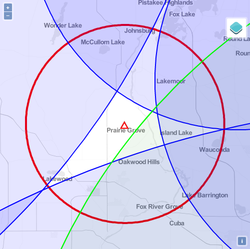
On the move map:
- The red triangle indicates the currently licensed location of the LPFM station.
- The green curve and shaded green area indicates the area where the station can be moved but would be subject to a second-adjacent channel waiver requirement.
- The blue curve and shaded area indicates where the LPFM station cannot be moved to as it would be short-spaced with other facilities.
- The red circle indicates the 11.2 kilometer move limit pursuant to § 73.870(a). (LPFM stations can only be moved further with a showing of overlap of the 60 dBu contours of the currently licensed and proposed locations.