myLPFM Help
Station Management
LPFM Channel Searching
Move station to a different location
Alternate channel at the same site
Reading Channel Search results
LPFM.us Station Directory
Miscellaneous Functions
REC Runway Slope Report
Feature avaialble for all myLPFM users.
The REC Runway Slope Report is our version of the FCC's TOWAIR tool for running preliminary checks only. This tool utilizes searches for airports within 5 miles of the proposed LPFM facility and utilizing the proposed overall tower and support structure heights indicated on an LPFM Channel Search, will determine if the tower structure meets the glide slope guidelines necessary to build a tower at this site without notification to the Federal Aviation Administration (FAA).
To run this report, you will first need to use either the
![]() Move LPFM Station or the
Move LPFM Station or the
![]() Check for Alternate Channels Search
to run a Channel Search and then on the Channel Search result, you follow the process to include facility details.
Then on the Channel Search result, click on the link next to FAA Tower Registration.
Check for Alternate Channels Search
to run a Channel Search and then on the Channel Search result, you follow the process to include facility details.
Then on the Channel Search result, click on the link next to FAA Tower Registration.
FCC Policy Basics
When registration is required
According to § 17.7 of the FCC Rules, FAA notification is required for any construction or alteration that is higher than 60.1 meters (200 feet) above ground level, when being built at an airport, when requested by the FAA or along any of these slopes:
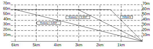
- 100:1 for a horizontal distance of 6.1 km from the nearest point on the runway if the runway is longer than 3,200 feet.
- 50:1 for a horizontal distance of 3.05 km from the nearest point on the runway if the runway is not longer than 3,200 feet.
- 25:1 for a horizontal distance of 1.52 km from the nearest landing or take off area for heliports.
Note that the elevation of the tower site and elevation of the end of the airport runway are taken into consideration when calculating where the top of the tower is in respect to the slope.
NOTE: The use of REC Runway Slope is not a replacement for the use of the FCC's TOWAIR tool. When filing an application, please verify these results in the FCC's TOWAIR Tool.
ALWAYS use the FCC TOWAIR Tool when filing an application
NEVER include an REC Runway Slope report in an application. REC assumes no liability for dismissed applications or undesired outcomes based on applications relying on REC Runway Slope data.
The 20-foot Rule
Structure registration is not required when the overall height of the antenna structure does not exceed 6.1 meters (20 feet) above the highest point on the support structure (a building) or for ground-based towers, no more than 20 feet above ground level.
Reading the Results
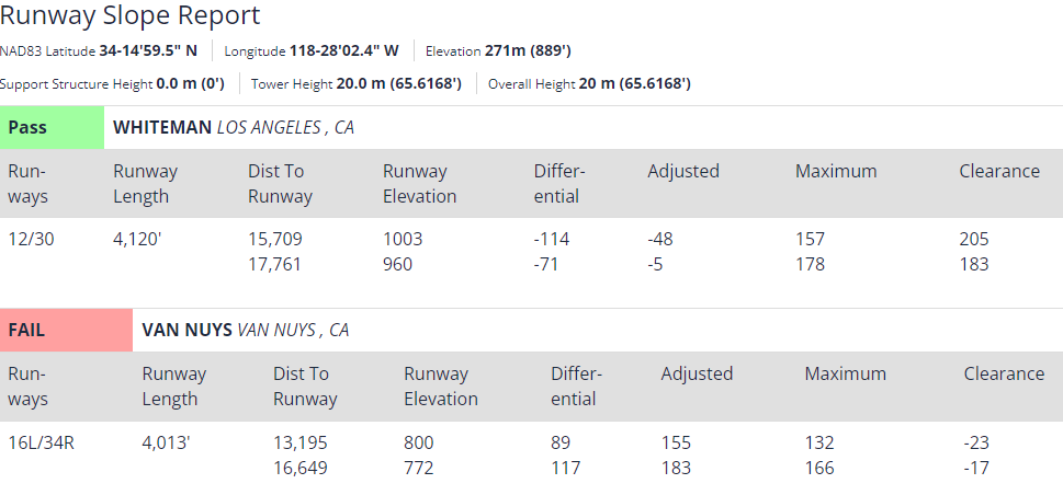
REC Runway Slope will return a preliminary pass/fail result for each airport runway. The data points, which are in feet instead of meters will show the following:
- Runway - The designation of the runway in both directions. You will see two numbers. That is the runway number at each end. Runway numbers are based on the heading of an aircraft landing or taking off from the runway. For example, a runway designated as 8 would be at 80 degrees. The second number represents the reciprocal value of 80 degrees which is 260 degrees or runway 26. Parallel runways include a letter designator for [L]eft, [R]ight or [C]enter.
- Length - The length of the runway in feet.
- Distance to Runway - The distance in feet from the tower site to each end of the runway.
- Runway Elevation - The elevations at each end of the runway.
- Differential - The difference in elevation between each end of the runway and the proposed tower. A negative number will indicate that the airport is at a higher elevation than the tower.
- Adjusted - This is the adjusted height of the proposed tower in respect to the elevations at each end of the runway. This is the height that must be under the slope limit.
- Maximum - This indicates the maximum adjusted antenna height based on the point on the slope. If the slope distance exceeds 200 (which it will if the LPFM tower is beyond 20,000/10,000/5,000 feet from the airport), it will default to 200. All antennas over 200 feet above ground level require FAA notification.
- Clearance - The number of feet under the slope the antenna is at. If this is a negative number, then the antenna is above the slope and FAA notification is required.